
Los cambios en el núcleo externo de la Tierra desencadenan cambios impredecibles en su campo magnético, una fuerza invisible que se extiende desde el interior de la Tierra hasta donde se encuentra con una corriente de partículas cargadas que emanan del Sol. Por ejemplo, en las últimas décadas, el polo norte magnético ha estado a la deriva hacia Siberia a una velocidad irregular. Esta migración puede afectar negativamente a la precisión de la navegación si no se compensa con un WMM actualizado. “Aunque el GPS es una gran herramienta para la navegación, está limitado en el sentido de que solo proporciona su posición. Su orientación, la dirección a la que se enfrenta, proviene del campo magnético”, dijo James Friederich, científico geodésico de la Agencia Nacional de Inteligencia Geoespacial de Estados Unidos. “Nuestros combatientes usan el magnetismo para orientar sus mapas. La cámara de su teléfono inteligente y varias aplicaciones pueden usar el campo magnético para ayudar a determinar la dirección hacia la que se enfrenta. Todos estos ejemplos necesitan que el MMM proporcione su orientación adecuada”.
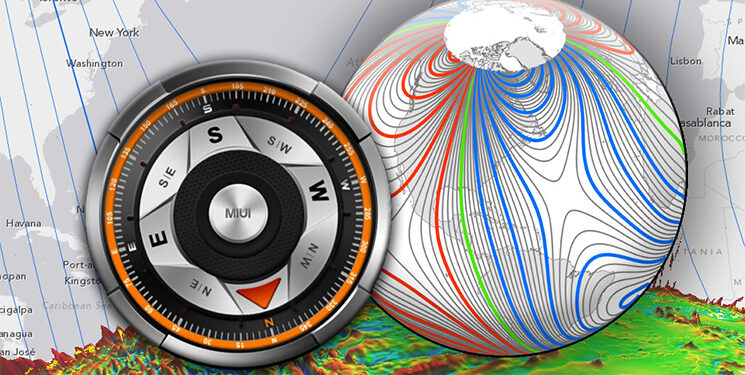
NOAA officials announced that the World Magnetic Model (WMM), a representation of Earth’s large-scale magnetic field and an indispensable complement to GPS devices used by NATO, the United States and United Kingdom militaries, as well as civil applications ranging from mineral exploration to smartphone apps, has been updated.
Changes in the Earth’s outer core trigger unpredictable changes in its magnetic field, an invisible force that extends from Earth’s interior to where it meets a stream of charged particles emanating from the Sun. For example, over the past few decades the North magnetic pole has been drifting toward Siberia at an irregular speed. This migration can adversely affect the accuracy of navigation if not compensated for by an updated WMM.
“We know the Earth’s magnetic field is constantly changing,” said Stephen Volz, Ph.D., assistant NOAA administrator for NOAA’s Satellite and Information Service. “But thanks to the environmental intelligence gathered from a wide array of platforms, including satellite observations, we can make vital updates to the World Magnetic Model and ensure the most accurate navigation for commercial applications.”
Updated every five years, the WMM, created using satellite observations of the Earth’s magnetic field, provides accurate magnetic field declination, the difference between true north and magnetic north critical for navigational safety. Scientists continuously survey the magnetic field and can precisely map the present field and its rate of change and then extrapolate changes into the future. WMM-corrected magnetic compass readings are not subject to ionospheric disturbances and work everywhere, including under the sea and in deep canyons.
“Although GPS is a great tool for navigation, it is limited in that it only provides your position. Your orientation, the direction you are facing, comes from the magnetic field,” said James Friederich, a geodetic scientist at the U. S. National Geospatial-Intelligence Agency. “Our war fighters use magnetics to orient their maps. Your smartphone camera and various apps can use the magnetic field to help determine the direction you are facing. All of these examples need the WMM to provide your proper orientation.”
Fuente: https://safety4sea.com