
Lidar es una de las tecnologías clave que ayudará en el despliegue de la infraestructura de la ciudad inteligente. Estos sensores brindan inmunidad a los datos espaciales a condiciones de poca luz mientras mantienen las protecciones de privacidad.
The main use case for light detection and range (lidar) technology will continue to be in the automotive sector as vehicle makers include the sensors in advanced driver assistance systems (ADAS) and future self-driving cars.
However, lidar use cases outside the automotive industry continue to grow as the technology is finding more ways to benefit smart farming, smart industry, surveying and mapping, and smart cities.
What is lidar?
Lidar is a remote sensing method used to measure the distances of objects — rocks, a dog in the street, walls inside a building, curves in the road, the size of packages and more. Much like radar systems that employ radio waves to measure objects, lidar uses lasers to calculate the distance of objects and the light pulses from these lasers generate 3D information about those objects.
A lidar system generally consists of a scanner, a laser and a receiver, however, it is common to find sensors like accelerometers or speedometers, inertial guidance systems and gyroscopes in lidar systems as well as GPS.
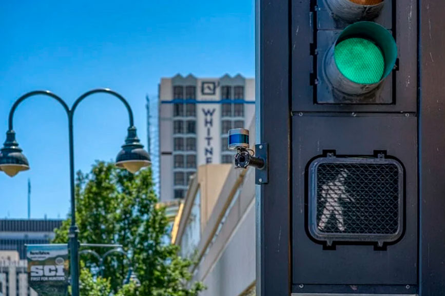
Inside vehicles, lidar is used to map the road ahead by spinning around firing lasers in all directions to measure objects in the car’s environment. Outside of cars, lidar can be mounted to tripods or a handheld system for measuring objects. It can also be mounted to a drone for surveying and mapping. In smart cities, lidar is attached to a traffic light or streetlamp or even a tower to get a bird’s eye view of neighborhoods.
Lidar in smart cities
Lidar is one of the key technologies that will help in smart city infrastructure deployment. These sensors provide spatial data with immunity to low light conditions while maintaining privacy protections.
This allows the sensors to gather information about the city during the day as well as night, something some cameras are unable to accomplish. Here are five ways in which lidar is being implemented in current and future smart cities.
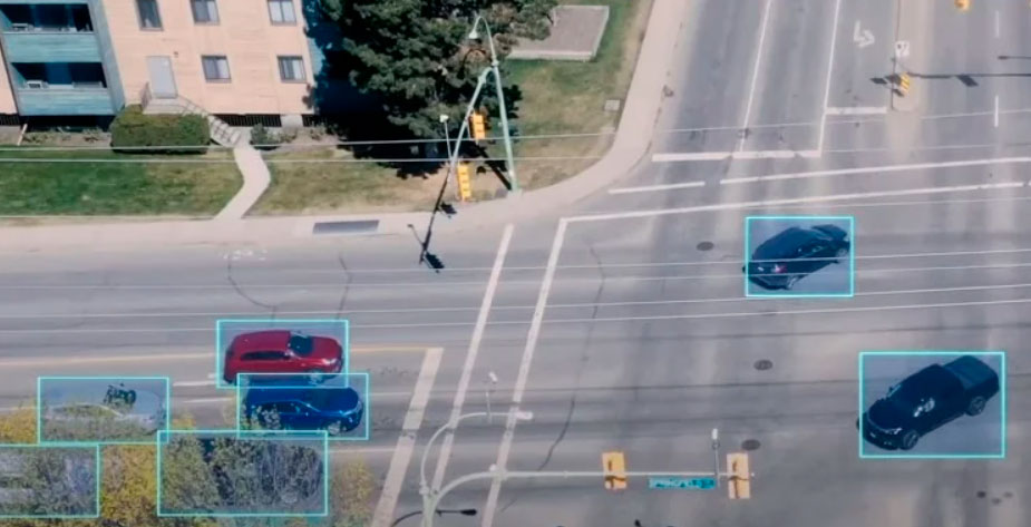
1) Traffic monitoring
Using lidar for traffic monitoring will be a big step for smart cities. Because these sensors operate in low light conditions, they can monitor traffic flows both day and night. 3D lidar can be deployed to count cars in busy intersections across multiple lanes of traffic.
Additionally, the technology can identify different types of vehicles with better accuracy than standard cameras. This helps municipalities gain a greater understanding of where problems exist and why.
Quanergy Systems is working with Parifex, a smart city vendor, to use 3D lidar for highway speed monitoring and enforcement in France. The project is being deployed by the French government to improve safety on roadways and to discourage excessive speeding.
Velodyne is also testing the technology in smart city projects by combining artificial intelligence with lidar for real-time data analytics and predictions to improve traffic and safety on city streets. Generating this type of data from the sensors will help in future autonomous vehicle mapping as well as data on pedestrian, bicycle and other vehicle habits in all environmental conditions.
Velodyne’s solution creates real-time 3D maps of roads and intersections and collects data on lighting and weather conditions year-round. A single lidar can be installed on a traffic pole and cover an entire intersection, compared to radar or camera-based systems that typically need multiple devices.
2) Pedestrian monitoring
Lidar can help municipalities identify high pedestrian traffic locations by counting the people at intersections, city parks, stadiums, downtown hot spots or other areas.
This information could be used for future city planning if more sidewalks are needed or foot bridges. It could also help in future and current pandemics when social distancing is needed.
Additionally, lidar can detect where a person is located and in which direction they are moving. This type of information could be used by law enforcement to look for individuals of interest or could help in Amber Alert situations.
3) Security management
Along the same lines as people counting, security management via lidar provides real-time detection, identification and tracking of people, vehicles and even small animals.
The lidar can be fine-tuned for custom-alarm perimeters to meet the needs of businesses or government buildings that require an additional layer of security.
4) Urban planning
Lidar surveying allows municipalities to create detailed 3D models of cities that can be used for:
- Military operations
- Disaster management and recovery
- City mapping
- New building construction
- Updating city maps
- Detecting urban environment changes
According to urban planning firm ACI USA Inc., much of this lidar mapping is currently done through planes flying over areas that need to be surveyed, self-driving cars equipped with lidar could make this process much easier and more detailed.
This ground-level approach could be used for future road evaluation and transportation planning. Also, it could be used to examine and identify issues with current urban areas or where new buildings and construction are planned.
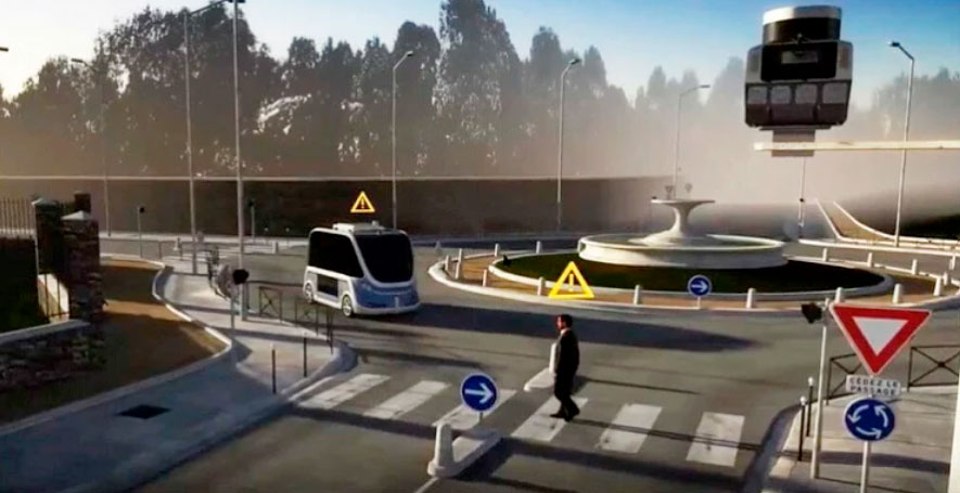
5) The self-driving car connection
Given that lidar will be a prominent technology used in self-driving cars, the connection to smart cities will be a natural fit. As vehicles become more connected, in smart cities vehicle-to-everything (V2X) will allow the car’s communication system to use sensors and other data sources to transmit and receive information.
Lidar in self-driving cars will constantly capture data about the vehicle and its surroundings and transmit this information to a central database to spread road conditions and roadway systems to other vehicles. This system could also relay road hazards or emergency situations to other vehicles to alert them to stay away or find a new route.
Smart parking will also be enabled through lidar and self-driving cars. A University of California-Berkeley study found that the U.S. had about 1 billion parking spaces for the 253 million cars and trucks on the road. That’s about four parking spaces for each vehicle.
Yet, parking is difficult to find in cities. Smart parking through V2X and lidar could identify open spots and relay the information to autonomous vehicles, allowing the cars to easily navigate to open spots and save on fuel consumption and headaches.
Conclusion
While these technologies are still some years off, lidar use cases in smart cities will enable municipalities to create safer streets for civilians while cutting traffic issues and improving parking situations. Also, when self-driving cars emerge, lidar will be used for urban planning and for enabling V2X communications.
Lidar is in nascent stages as well and the industry could see more applications for the technology in the future as more smart city projects emerge.